Blog

The Wu Tip Shan Path of Fanling

The Wu Tip Shan Path of Fanling

The weather has not been too good lately so I opted for a short hike in my neighborhood.  The Wu Tip Shan Path of Fanling serves a good purpose.  I clocked in some pretty good exercise and saw some decent views on the way. Entrances 

The Jubilee Battery

The Jubilee Battery

It took me a while, with many confusing turns, before I found the Jubilee Battery.  For there is only one ruins of the battery that is accessible by proper roadways.  The Jubilee Battery’s Gun Emplacement 2 lies within the University of Chicago Francis and Rose 

The Siu Lo of Yuen Long

The Siu Lo of Yuen Long

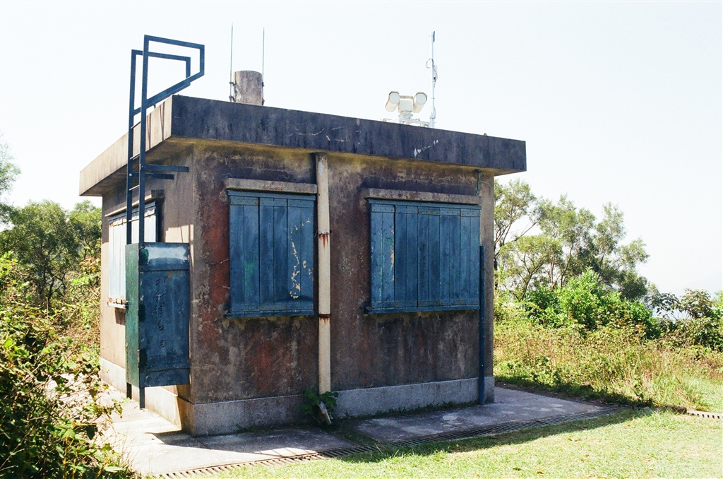
Update as of August 2023: The area of the heritage site has been blocked off from visits. It is likely due to the revitalization and construction work that was approved. The old trees with their aerial roots that hovered over the building have been removed. It looks like one would have to wait a bit before it is open again and dressed in new clothes.

As soon as I saw its photographs online, Siu Lo captured my imagination.  I decided to pay a visit.

The Story of Siu Lo

Siu Lo is an abandoned old house on Tai Tong Road, Yuen Long.  The original owner of the building was named Chan Mo Ching (transliteration), a merchant that operated a business in Indonesia.  Chan Mo Ching returned to his hometown in China during WWII.  Thereafter, his relatives lived in Siu Lo.

There are rumours that the house has once been the assembly point for the self-defence forces of the Hong Kong Independent Battalion of the Dongjiang Column.  This particular fighting force was a locally-organised guerilla force throughout the war and the Japanese Occupation of Hong Kong.

Siu Lo’s owner Chan Mo Ching did return to the house after WWII.  He and his family then lived there until the late 1970s.  Despite a chapter full of intrigue in its history, Siu Lo has been vacant, and thus left in ruins, since the family left.  Chan’s descendants held onto its ownership until 2016, when Tang Shing Bor’s family enterprise bought the land forHK$63 million.  Tang Shing Bor died in 2021.  Thereafter his son sold this land to Kato (Hong Kong) Holdings Limited for HK$65 million.

The Town Planning Board opined in an application for development of Siu Lo (more below) that “Siu Lo itself is not related to a very prominent figure in Hong Kong, yet its history is subtle to lie with the development and lives in villages in Yuen Long.”  It is a Grade 3 Historic Building.

Online sources suggest that this house is haunted.  Not only that, it tops the list for the most haunted in Hong Kong as well.  Neighbours have heard sounds of playing mahjong there even after the abandonment.

The Structure

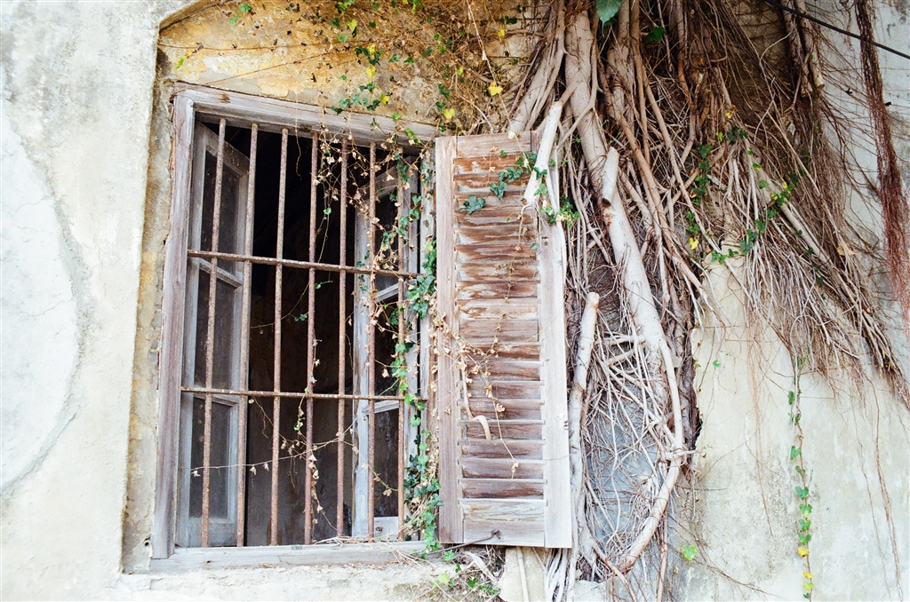
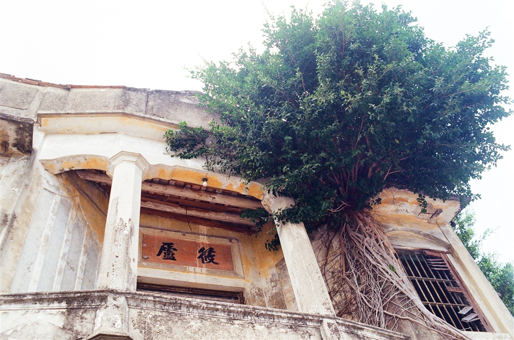
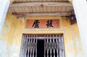
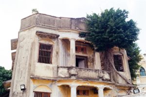
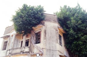
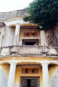
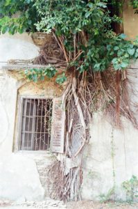
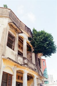
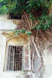
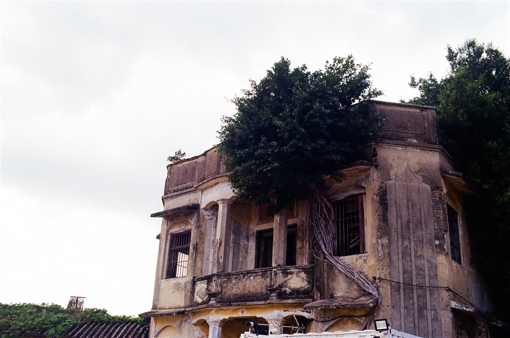
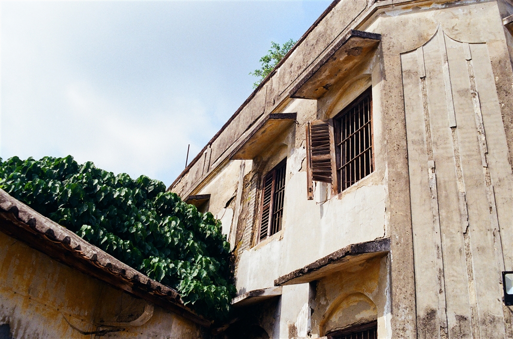
Built in the 1940s, the old house shows mixed eastern and western features.  According to Hong-Kong-Heritage.com, the name plaque atop the entrance gateway, the verandah, and the balcony on second floor are common and traditional features for structures in southern China.  The two stone pillars on the side of the gateway, with corresponding pillars on the second floor balcony, however, are a touch of western architecture.

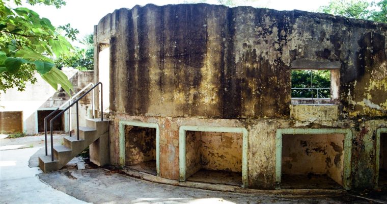
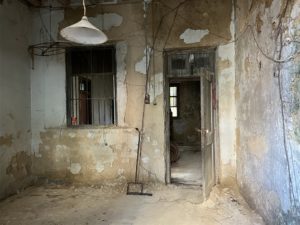
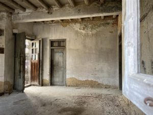
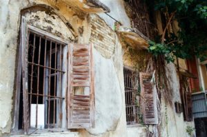
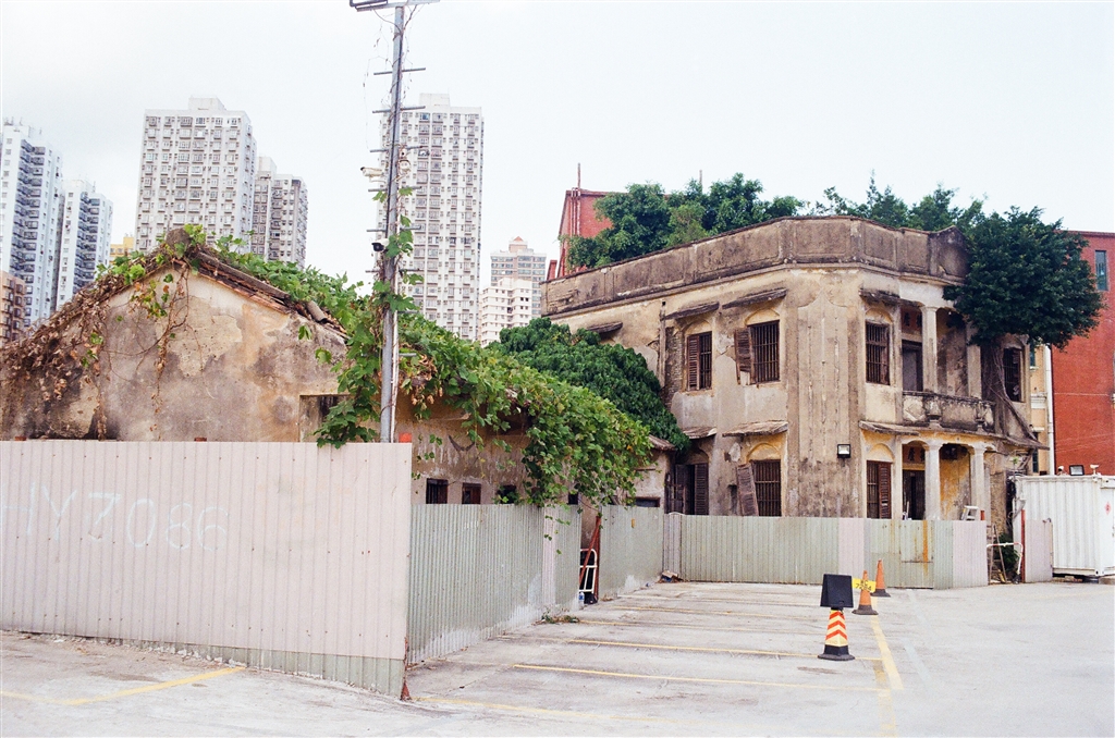
The building has remained this way, authentically and in ruins, since the late 1970s.  The typical signs of abandonment show amply on the structure.  A tree (or maybe more than one) has grown its roots over the broken windows.  Nature has extended its merciless hand over it.  It is eerie indeed, and perhaps that is also the reason why haunted stories about Siu Lo circulated.

Current Developments

When I arrived at the site, I was a little taken aback because the area is now a public parking lot.  I did have to pay a parking fee for my car to park there, just to take photos of the building.  The minimum spending is two hours, but I negotiated with the kind man there to pay only one hour for $14.

Like the Pun Uk (Yam Wah Lo) near Pok Oi Hospital, the former owner of Siu Lo had plans to revitalize Siu Lo.  I located online an application for use/development for the whole lot of Siu Lo, including the area that is now a parking lot.  The application suggests erecting a five-storey building, plus a one-level basement, to serve as an elderly care home on site.

For Siu Lo itself, on the other hand, the plan is to conserve it fully.  Restoration will proceed with both the two-storey main structure, and the one-storey annex.  When restoration completes, visitors can visit the site in its renewed glory.

I must say, however, that the current Siu Lo in ruins has a beauty of its own.

This said application has been approved by the Town Planning Board already.  Finally, in May 2021, Tang Shing Bor’s family enterprise sold Siu Lo to Kato (Hong Kong) Holdings Limited.  The Notice of Discloseable Transaction seems to suggest that the already-approved plan for development of an elderly care home will go forward, as well as the conservation of Siu Lo.
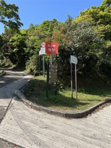
How to Get There

Siu Lo is located next to the Caltex on Tai Tong Road, Yuen Long.  By public transport, perhaps you can take the light rail and get off at the Tai Tong Road Station, then walk about 10 minutes.

If you are not able to search its English name on Google Map, you will find it if you point your location marker to the Caltex on Tai Tong Road.

Sources

Hong-Kong-Heritage.com on Siu Lo (Chin).

Weekendhk.com, Neighbors with the Ghosts: Building An Elderly Home Next to Yuen Long’s Siu Lo, January 24, 2022.

Town Planning Board, Broad Development Parameters of the Applied Use / Development in respect of Application No. A/YL/256.

Kato (Hong Kong) Holdings Limited (Stock Code: 2189), Discloseable Transaction Acquisition of Lands, 21 May 2021.

Hong Kong Museum of History, Newsletter, October to December 2013.

The Lau Village Houses in Tung Shing Lei

The Lau Village Houses in Tung Shing Lei

I was intrigued by the Lau Village Houses in Tung Shing Lei, Yuen Long after seeing photographs online.  Upon some research, I learned that the property was the subject matter in a highly contested court case.  Therefore I will draw on the case to report 

A Failed Attempt at Reaching Hung Shek Mun

A Failed Attempt at Reaching Hung Shek Mun

Ever since I visited Chek Chau (Port Island), I have been fascinated by sceneries of red earth in Hong Kong.  From fellow bloggers I learned that the seaside at Hung Shek Mun presents stunning views of such.  I debated for quite a while, because the 

Sunset at Lam Hang Shan, Tin Shui Wai

Sunset at Lam Hang Shan, Tin Shui Wai

I was looking for easy hiking trails in Tin Shui Wai and found sources online discussing Lam Hang Shan.  It is a small hill in northwestern Hong Kong.  The location presents wonderful views of the Hong Kong-Shenzhen Western Corridor (Route 10), which includes the Shenzhen Bay Bridge.  Certainly, the Deep Bay (Shenzhen Bay) and skyline of Shenzhen are also in full view there.

I parked at Tin Chak Estate.  After exiting the carpark, I went toward the jogging and biking trail by the drainage channel.  There is an overpass northward, providing the way over the drainage channel.  On the overpass, if you look west (straight ahead), Lam Hang Shan is right there.

Photos from left to right: the jogging trail west of Tin Chak Estate; Go up the overpass; View on the overpass; Lam Hang Shan in view.

Photos above: Views of the drainage channel on the overpass.

I turned left at the end of the overpass and descended onto ground level.  Right there you will see a somewhat obscure opening onto the motorway (Tin Ying Road).  Although it does not look like an official exit, do take this path and cross the motorway.  Beware of oncoming traffic on both directions.  It is not a proper road crossing.

Photos above: Once at the end of the overpass, turn left and descend onto ground level.  You will notice this somewhat obscure opening on your right.  Go through it, and then cross Tin Ying Road (photo on the right), be very careful.

Because Lam Hang Shan is not a standard trail, things do not seem official but the paths are clear.  This is the entrance into Lam Hang Shan.

There are a number of ways to go up the hill, and I took the quickest shortcut.  I went straight and headed up the mountainous path.  After these steps (the photo far right), I turned right.

This is the view of the path on the right (photo on the left).  Very soon I came upon this path on my left (photo on the right).  I started climbing it.

However, this way is somewhat challenging, especially if you are going with children.  If it is too rugged, please do not turn left and keep on going on the path (photo on the left) and it will eventually lead you to the top of the hill.

Allow 40 minutes to 1 hour of walk from Tin Chak Estate to the top of Lam Hang Shan.

The View

When you are up on the hill, you will see 360 degree views of Tin Shui Wai’s heavily-populated housing estates, but with nature as its background.

Photos: Left – Views of the south in Lam Hang Shan.  Right – Views of the north.

Looking west, there are unobstructed views of Shenzhen’s skyline, seemingly extending to eternity.  And this would be the perfect backdrop for the sunset watching.

There were many photography enthusiasts there on the day that I visited.  A photographer that I met told me that it is actually better views when there are clouds.  It was a clear sky that day.  Next time I know what day to pick.

About Route 10

I think it suffices to simply quote the Wikipedia on Route 10:

Route 10 is the newest trunk route in the Hong Kong Strategic Route and Exit Number System. It is a 10.9 km dual carriageway with three lanes in each direction, consisting of the Kong Sham Western Highway (formerly Deep Bay Link) and the Shenzhen Bay Bridge of the Hong Kong–Shenzhen Western Corridor, connecting the Yuen Long Highway (Route 9) in Lam Tei to Shenzhen via border checkpoint Shenzhen Bay Port. The trunk route is the only[citation needed] one in Hong Kong that terminates at a border crossing (and is partly built within the area of Shenzhen Municipality).

See Wikipedia’s entry on Route 10 here.

How To Get There

Bus Routes 265B, 265M, 276A stop at Tin Chak Estate.  By rail, Light Rail Route 706 stops at Tin Yat Estate and you can walk about 10 minutes to Tin Chak Estate from there.

Reminder

Perhaps bring a good flashlight with you if you plan on visiting Lam Hang Shan for sunset watching.  In March, the sun sets around 6:30pm.  But if there are clouds, they will remain colorful for a while.  Some people stay for a little longer to watch the majestic colors of sunset.  However, there was no such view on the day that I visited.

The quick shortcut that I did going up would not be suitable for coming back down.  Therefore go down via another safer path.  There are many pathways there that will lead you back to ground level reasonably safely.

The Fu Tei Au Tsuen Village of Sheung Shui

The Fu Tei Au Tsuen Village of Sheung Shui

Many villages in the New Territories only come into the media spotlight when the government takes action to resume the land.  Such is the case of the Ping Yeung Village in Fanling, where villagers painted murals in the village as part of their effort to 

A Two-Loop Walk at the Shek Lei Pui Reservoir and Kowloon Reception Reservoir

A Two-Loop Walk at the Shek Lei Pui Reservoir and Kowloon Reception Reservoir

We are finally seeing sunny days in Hong Kong and I seized the day for a short walk.  The itinerary was originally just the loop at Shek Lei Pui Reservoir.  But I decided to do a further loop at the Kowloon Reception Reservoir in the 

A Walk in Po Toi Island

A Walk in Po Toi Island

Po Toi Island is known locally as the “South Pole of Hong Kong.”  For Po Toi Island is the southernmost inhabited island within Hong Kong’s waters.

The History of Po Toi Island

According to the Wikipedia, the Chinese word “po” means “floating,” and therefore the name Po Toi means a “floating platform.”  It is believed that the island acquired its name due to its relatively flat terrain (which turns out to be somewhat untrue, as its peaks are almost 400 meters high, see below).  Also, the word “toi” could have referred to the seaweed that the islanders used to harvest.

The existence of the Rock Carving (see more below) suggests that early settlement in Po Toi Island goes as far back as 3,500 years.  In modern times, the residents of Po Toi Island lived by fishing, seaweed harvesting and farming.  In the 1950s, residents numbered 500.  At one point, two schools on the island educated the children.  However, by the 1980s, due to population decline, the schools both closed.

Due to the lack of facilities in the island, most residents have moved out to live elsewhere.  We asked the people there if they still live in the island.  They told us that very few stay overnight.  Although there are still signs of business activities that cater to the visitors.

The Trail

From the Po Toi Island Pier we headed over the Route No. 1, which is the Po Toi Island Country Trail, to begin our journey.  We first came upon the Mo’s Mansion.

The Mo’s Mansion was home to a rich family.  Mr. Mo built this mansion in the 1920s.  There are rumours that it is now haunted.  As the story goes, the Mo’s disappeared from their home in one night.  The true story is probably a lot more sensible.  One night, the pirates ransacked the mansion when the residents were watching a show.  Upon returning, the residents decided to pack their bags and leave the house for good.  Thus they “disappeared” overnight.

The first part of the route is a steady incline from Po Toi Pier to the Ngau Wu Teng Pavilion.  We detoured a little to seek a way to see the two peaks, Tai Pai Tong Teng (372m) and Tong Tau Teng (392m).

Photo: View on our detour, but we decided to head back the standard path.

However, the tracks are not well-trodden so we went back to the standard path.  We soon arrived at the Ngau Wu Teng Pavilion for a short break.

Photo: View of Ngong Chong Hill at the Ngau Wu Teng Pavilion

The trail then proceeds to a steady descent onto the hill of Ngong Chong.  At the ferry, the crew announced that the ferry would be departing Po Toi Island at 2:30pm that day.  We figured that we did not have enough time to see the hill of Ngong Chong.  The special sites there include Lighthouse 126, the Palm Cliff (Buddha Hand Rock), the Tortoise Climbing Up the Mountain, and the Supine Monk.

So we headed back to the direction of the pier.  Our final stops were the Rock Carving at Nam Tam Wan, Kwan Kee for a snack and the Tin Hau Temple on the western coast of the island.

The Geology of Po Toi Island

The Po Toi Country Trail shows very picturesque views of a rocky terrain.  The Hong Kong Government’s CEDD has a very technical introduction on the mostly granite formation of Po Toi Island.  Suffice to say, the granite formations of Po Toi Island are considered relatively young in Hong Kong with 140 million years behind them.  They share the same age and formation as the granites of Cape D’Aguilar, Stanley, Shek O and Beaufort Island.

The surfaces of the granite at Po Toi Island are coarse and medium- to fine- grained.  “On the coast the granite forms cliffs of pink to light brown, slightly to moderately weathered rock.”  Indeed, the spectacular rocks on the hill of Ngong Chong are the results of erosion.

The Rock Carving of Po Toi Island

At the end of the trail, along the southern coast of Po Toi Island lies the Rock Carving of Po Toi Island.  This is one of the nine rock carvings found in Hong Kong.  In previous occasions, I have visited the Lung Ha Wan Rock Carving, the Big Wave Bay Rock Carving, and the Cheung Chau Rock Carving.

The Rock Carving of Po Toi Island was discovered in the 1960s.  There are two groups of carving on-site.  One showing spiral patterns, another showing straight and curved lines that are “more abstract.”

The existence of these rock carvings on the coastal areas of Hong Kong suggests that the very early settlers of Hong Kong were sea-faring people.  These patterns on the carving were probably meant to elicit the power of the ocean.  There is no settled view on the date of these carvings.  However, because of their similarity to the patterns of bronze vessels of the Bronze Age, it is perhaps good enough to say that they were of the Bronze Age.

Like all other rock carvings in Hong Kong, the Rock Carving of Po Toi Island is a declared monument.

Food

Po Toi Island is known for its seaweed.  Back in the old days, seaweed harvesting was a main industry in the island.  I bought a pack of locally-harvested kombu and it was very good.

We stopped at Kwan Kee, which was the first restaurant that we came upon at the end of the trail.  Naturally, they serve food with the famous seaweed.  We had spam and egg noodle with a generous bunch of seaweed.  The drinks are also quite special, I ordered a bottle of lemonade with China Barley.

There is a proper seafood restaurant along the beach, close to the pier.  We did not stop by for a seafood meal, and maybe we can do it on a next visit.

The Tin Hau Temple

Like so many other inhabited islands in Hong Kong, Tin Hau is the resident deity in Po Toi Island.  For Tin Hau is the Goddess of the Sea.  On this day that we visited, however, the temple was undergoing renovations.  I only managed to snap a quick picture outside.

The Tin Hau Temple has existed since the 12th year of the Daoguan Reign (1832).  The floral tribute grabbing contest takes place on Tin Hau’s birthday each year.  It is unclear whether the islanders have continued this tradition today.

Reminders

There is usually just one ferry on schedule to Po Toi Island on Tuesdays, Thursdays, Saturdays, Sundays and public holidays.  Similarly, there is also only one ferry on schedule to return to Hong Kong Island.  Please study carefully the ferry schedule here.  On different days the ferry either departs from the Aberdeen Pier or the Stanley Pier.

Because there is really only one scheduled ferry to Po Toi Island, be sure to arrive at the pier a little earlier than the scheduled departure.  We went on a Tuesday and when we arrived at the pier at 9:45 or so, the ferry was almost full.  Once the ferry is at full capacity it will sail away.

On this Tuesday, we boarded the ferry at 10:00am and arrived at Po Toi Island in less than an hour.  The ride from Stanley would take about half hour.

Sources

Historic Descriptions On-Site at Po Toi Island.

The Wikipedia on Po Toi Island.

The Wikipedia on Po Toi Island (Chin).

“Hong Kong’s South Pole” with Thousand-Year-Old Rock Carving (Chin), Unu Travel;

The CEDD on Po Toi Granite.

The World of Geology, hktraveler.com.

From Kam Shan Country Park to the Smugglers’ Ridge

From Kam Shan Country Park to the Smugglers’ Ridge

The trail of the day is a 5km walk on the Smugglers’ Ridge.  I decided to head from the Kam Shan Country Park (also known as Golden Hill Country Park), then to Smugglers’ Ridge via the Smugglers’ Pass.  I exited through the Shing Mun Reservoir.