Beautiful Sha Tau Kok – The Potholes of Shek Pan Tam

It took me three attempts to find the beautiful Shek Pan Tam, aka Ka Lung Tam (Ka Lung Pool) in the Nam Chung area of Sha Tau Kok.
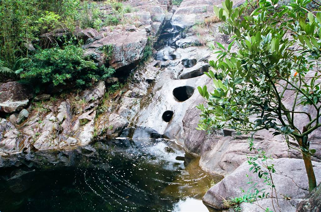
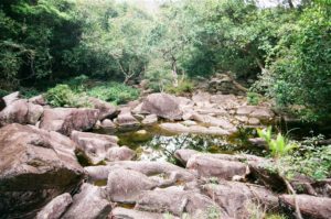
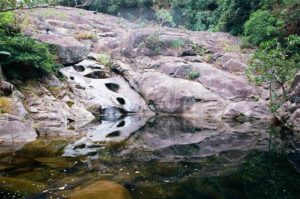
The potholes of Shek Pan Tam (meaning the stone-slab pool) are the largest such natural phenomenon in Hong Kong. I fell in love with the scenery when I saw its introduction in a hikers’ guide.
Potholes: Nature’s Artwork
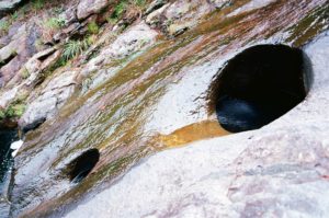
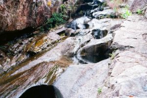
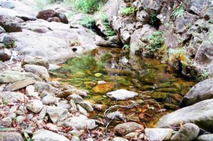
These potholes come about due to water erosion of granite, sandstone or conglomerate surfaces. The water carries small pieces of sediments. As the stream passes through, the sediments in the water swirl and slowly erode the granite, and these potholes form. The holes then become a well due to consistent erosion, each well collecting the flowing water. Some are deep enough to allow a whole person to submerge in. Indeed, at Shek Pan Tam, many visitors would dip their whole bodies into the potholes for a nice bath.
My first attempt to find Shek Pan Tam failed, and led me to the beautiful Youde Memorial Pavilion. That was all very good but I insisted on seeing the pool. Last Thursday, I tried a second time. I researched for better directions on the hiking blogs.
I went to the Pat Sin Leng Country Park Luk Keng Management Centre, along the Wilson Trail Section 10. According to the instructions, outside the public toilet there is supposed to be a signpost pointing to the pool. I drove very carefully up the narrow mountainous pathway to the Management Center, but I did not see any signs.
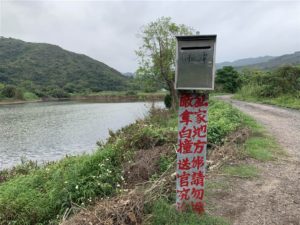
When I passed through the Nam Chung area last time after I visited the Youde Memorial Pavilion, I remember seeing a sign that says Shek Pan Tam in the Nam Chung villages. So I decided to try my luck there. I drove down the mountainous path back to the Nam Chung Main Road, and having passed the Nam Chung Public Toilet, there is an opening to a village with a metal mailbox that says Shek Pan Tam.

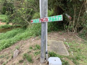
On this second try, I knew I found the way. About after a 15 minute walk through the beautiful village and its fish ponds, I saw signs for Shek Pan Tam.
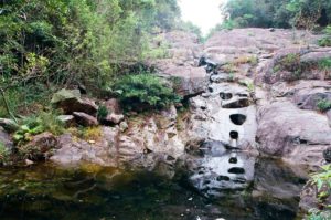
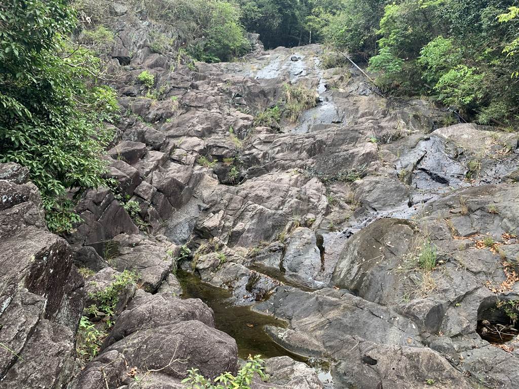
The Ping Ka Stream
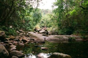
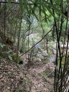
I then followed the Ping Ka Stream upwards. The views on the stream were perfect signs to me. I knew that if I made it this time, it would be a wonderful experience. There was no one else around. A clear stream flowed through the rocky landscape.
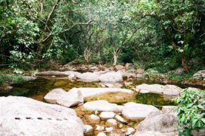
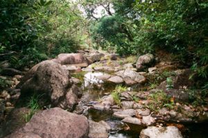
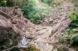
I must say, however, that on this first time hiking the stream it was not so easy. Hiking was always a recreational endeavor for me, and this stream presented a difficulty that I had never encountered before. I tried grabbing onto the low-hanging tree branches for support. Both my knees are weak with prior injuries, so I had to test the support point before laying my body weight on my lower limbs. It took a while, and then I came upon the cliff.
I debated what to do. The stream was already quite a stretch of abilities for me. And then there is this cliff. I did not know if indeed I would find the potholes after climbing this cliff. And at that moment, my better judgment told me to give up. I had no previous experience with rock climbing.
With disappointment, I headed back to the village. I saw a villager working in her front yard. She said, “yes, that is the way to Shek Pan Tam and of course you would have to climb the cliff!” I had my question answered, the cliff must be overcome before I find the scenery that I have been obsessed with for weeks.
I showed her the picture of the cliff, and she showed me the way to climb it, “make sure that you head up using the rocks on your left,” she said, “and also, when you leave, do not climb back down. You climb up for another set of rocks, then follow the bamboo pathway up to the mountain.” I then realized that would have been the way from the Management Center, “oh the sign that used to point to the potholes was taken down about two years ago,” she told me.
It all became clear to me. But I went home because it was getting dark in the late afternoon.
That evening, I lied in bed unable to sleep. The wish to see the potholes became a burning desire.
Finding the Potholes
On Friday morning, I headed out again, and as I passed through the last village property before entering the Ping Ka Stream, the owner saw me. “Didn’t you come yesterday?” I frankly told him that I was too scared to climb the day before. “Here’s what you have to do,” he said in an expert-like manner, “stay on your left on the cliff. Once you climb up you will see the pool. Then when you are done, you head to rocks on your right and climb up further more. Keep to your right, and you will see four inlaid tiles on the ground. That is an indication that you are on the right track. Keep going on your right, and follow the ribbons on the trees. You will have to climb further up to reach the Management Center up the mountain, then head back on descent and loop back to your car in the village. Be very careful, it rained last night and it might be slippery, and plus you are going alone.”
With this very detailed instruction, I marched onto the stream. The second time trekking the stream was slightly easier, as I already knew the rocks and their support level. I took a deep breath before the cliff. This is it!
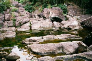
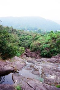
I took about twenty to twenty-five minutes to climb the cliff very carefully, taking some breaks in-between. The view on the mid-level of the cliff, looking far onto the mountains, was exceptional.
I took each maneuver step-by-step, testing the support and the slippery levels. I did slip slightly once or twice, but I managed to find grabbing points for leverage.
Leaving The Scenery of Tranquility
In Chinese, we describe sublime scenery with the phrase, “a cherry blossomed stream out of this world.” I took my time crafting my photographs. The water flowed out of the potholes in a continuous stream. I had never seen a scenery so tranquil in Hong Kong.
I spent about thirty to forty minutes admiring the potholes. To leave, I headed upwards on the right. The climb was not as dangerous this time. The bamboo-lined pathway up the Management Center was very, very narrow and steep. If visitors would like to take this pathway downward to see the potholes, my advice is to climb down facing the ground and using all fours, instead of descending the steps as we normally do.


If anyone would like to take the descent onto the potholes from the Management Centre on the mountain, look for the trees with tied ribbons across from the public toilet. The sign pointing to the potholes no longer stands.
Whether you take the way downward from the mountain or upward the Ping Ka stream from the village, there is danger involved. If you take the way via the village in Nam Chung, be sure that you will greet very fierce dogs guarding the last village property before entering the Ping Ka Stream. Yes, the kind owner of these dogs gave me detailed instructions on how to maneuver the cliff, his dogs were nonetheless very scary and they did roam around freely.
Once having overcome the difficulties, the view is well worth it. Although I did this trip alone, I probably would never do it again. It is certainly not a good idea to go alone. There was a fatal accident at Shek Pan Tam a few years ago. Therefore never underestimate the danger involved. Warning and warning once again.